

The Canary Islands Government has said it is monitoring an earthquake swarm on the small island of El Hierro where in excess of 620 tremors of low magnitude have been recorded in the past week.
Earthquakes, measuring between 1 and 3 on the Richter Scale, continued on Monday and more ahve been registered agin on Tuesday. The majority of earthquakes are being recorded at a depth of between 5km and 15 km.
The Ministry of Economy, Finance and Government Security Canary has convened the first ever meeting of the Steering Committee and Volcanic Monitoring, reflected in the Specific Plan Protection Civil and Emergency for Volcanic Risk, given what it described “the significant increase in seismic activity”.
A statement (translated from Spanish) issued following the meeting outlined: “This committee met (Friday) at the headquarters of the Directorate General Security and Emergency Tenerife, established after the assessment of information gathered from seismic and volcanological last July 17 by the National Geographic Institute (IGN) and Volcanological Institute of the Canary Islands, the situation is total normal for the green light for the information population, activating mechanisms for monitoring and oversight needed to coordinate the actions of self civil population and information contained in the Plan.”
“According to data provided by the seismic monitoring station IGN’s located in Valverde, one can conclude that from the noon on July 17 there has been a significant increase of low magnitude seismic activity in the municipality of Border of the island of El Hierro. To improve the location of this activity, has deployed a seismic network densification operational since July 21 has helped increase the number of earthquakes located, and can be viewed at Web www.ign.es”, the statement added.
620 Earthquakes Recorded On El Hierro In The Canary Islands
By Mark Dunphy – Tue Jul 26, 1:22 pm
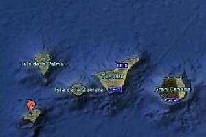
Location of tremors on El Hierro. Image Google EarthThe Canary Islands Government has said it is monitoring an earthquake swarm on the small island of El Hierro where in excess of 620 tremors of low magnitude have been recorded in the past week.
Earthquakes, measuring between 1 and 3 on the Richter Scale, continued on Monday and more ahve been registered agin on Tuesday. The majority of earthquakes are being recorded at a depth of between 5km and 15 km.
The Ministry of Economy, Finance and Government Security Canary has convened the first ever meeting of the Steering Committee and Volcanic Monitoring, reflected in the Specific Plan Protection Civil and Emergency for Volcanic Risk, given what it described “the significant increase in seismic activity”.
A statement (translated from Spanish) issued following the meeting outlined: “This committee met (Friday) at the headquarters of the Directorate General Security and Emergency Tenerife, established after the assessment of information gathered from seismic and volcanological last July 17 by the National Geographic Institute (IGN) and Volcanological Institute of the Canary Islands, the situation is total normal for the green light for the information population, activating mechanisms for monitoring and oversight needed to coordinate the actions of self civil population and information contained in the Plan.”
“According to data provided by the seismic monitoring station IGN’s located in Valverde, one can conclude that from the noon on July 17 there has been a significant increase of low magnitude seismic activity in the municipality of Border of the island of El Hierro. To improve the location of this activity, has deployed a seismic network densification operational since July 21 has helped increase the number of earthquakes located, and can be viewed at Web www.ign.es”, the statement added.
Latest tremor activity from Institute Volcanological de Canarias
The western end of El Hierro Island (Canary Islands, Spain). Image Eckhard PecherEl Hierro, a 278.5 km2 island, is situated in the most southwestern extreme of the Canaries. The island was formed after three successive eruptions, and consequent accumulations, the island emerged from the ocean as an imposing triangular pyramid crowned by a volcano more than 2,000 metres high.
The volcanic activity, principally at the convergence of the three ridges, resulted in the continual expansion of the island. A mere 50,000 years ago, as a result of seismic tremors which produced massive landslides, a giant piece of the island cracked off, crashed down into the ocean and scattered along the seabed.
This landslide of more than 300km3 gave rise to the impressive amphitheatre of the El Golfo valley and at the same time caused a tsunami that most likely rose over 100 metres high and probably reached as far as the American coast.
According to ElHierro.com: “Although over 200 years have elapsed since the last eruption, El Hierro has the largest number of volcanoes in the Canaries with over 500 open sky cones, another 300 covered by the most recent outflows, and some 70 caves and volcanic galleries, notably the Don Justo cave whose collection of channels surpasses 6km in length.”
El Hierro is located south of Isla de la Palma (population 86,000), currently the most volcanically active of the Canary Islands. About a half a million years ago, the volcano, Taburiente, collapsed with a giant landslide, forming the Caldera de Taburiente. Since the Spanish occupation, there have been seven eruptions. In a BBC Horizon programme broadcast on October 12, 2000, two geologists (Day and McGuire) hypothesised that during a future eruption, the western flank of the Cumbre Vieja, with a mass of approximately 1.5 x10¹⁵ kg, could slide into the ocean. This could then potentially generate a giant wave which they termed a “megatsunami” around 650–900 m high in the region of the islands. The wave would radiate out across the Atlantic and inundate the eastern seaboard of North America including the American, the Caribbean and northern coasts of South America some six to eight hours later. They estimate that the tsunami will have waves possibly 160 ft (49 m) or more high causing massive devastation along the coastlines. Modelling suggests that the tsunami could inundate up to 25 km (16 mi) inland – depending upon topography.